C-ITS – an overview
"Cooperative Intelligent Transport Systems" (C-ITS) describe technologies and standards to connect vehicles with other vehicles (V2V) and infrastructure (V2X). The idea originated in the automotive industry and aimed at increasing road safety. However, with the same standards, a number of functions and different tasks in traffic control can be implemented. Martin Franke, SWARCO product manager for C-ITS in Germany, gives us an overview.
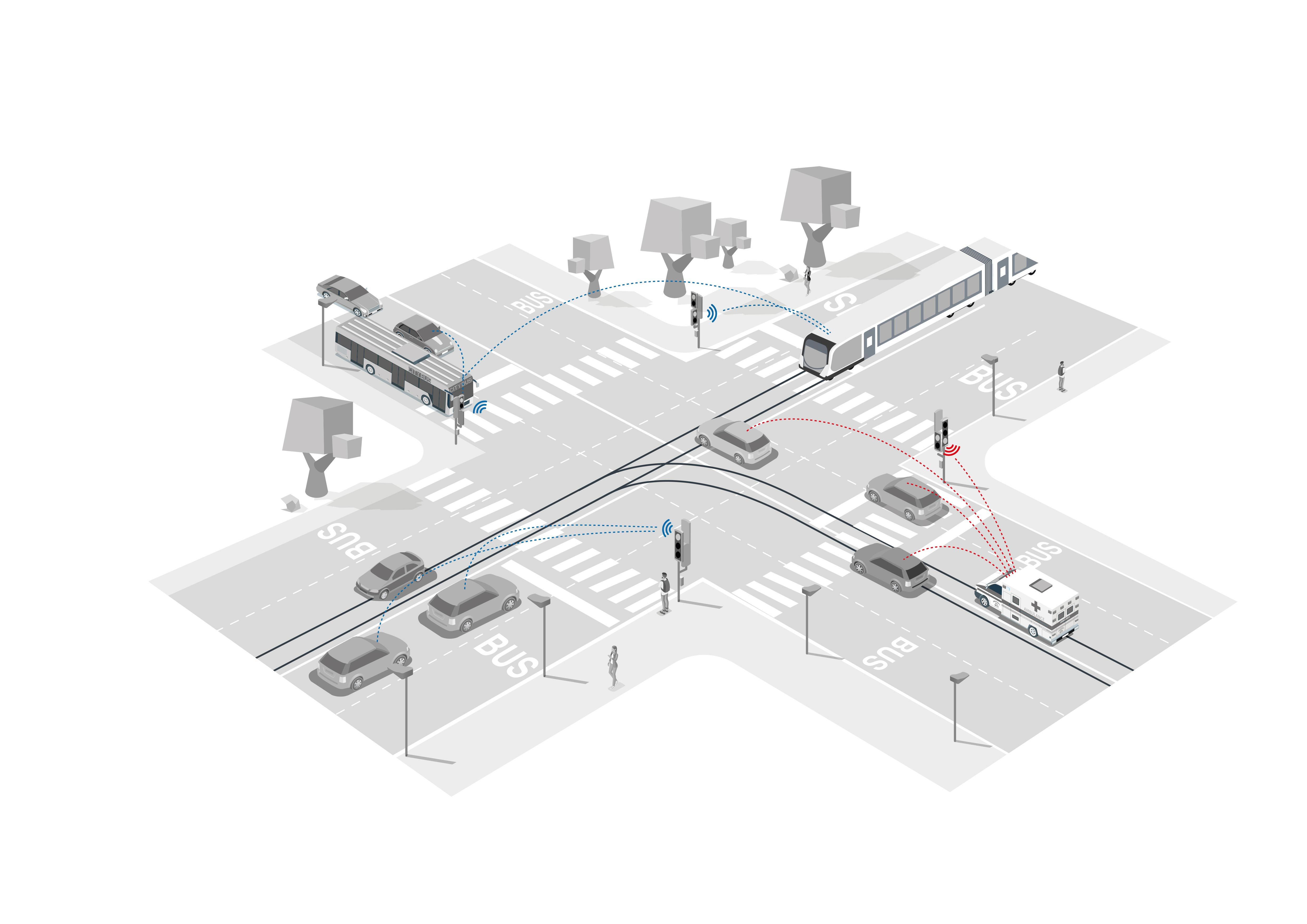
Prioritise rescue services
A message emitted by special rights vehicles firstly informs other road user on an approaching emergency vehicle, triggering the formation of an emergency corridor, and secondly triggers a particular program at signal-controlled intersections switching the traffic light to green in the travel direction of the rescue vehicle. Thus, the driver knows that it is safe to enter the intersection without other vehicles or pedestrians crossing his way.
Prioritise public transport
Due to the reorganisation of the non-public mobile land radio, changes are required in the communication between public transport and traffic light systems. Here too, C-ITS communication can be used: On the one hand, C-ITS can also send R09.16 VDV standard telegrams and adopt modern technology and planning in the traffic light systems. On the other hand, C-ITS offers also the possibility to track the vehicle movement up to the traffic light, adapt the signal phase and give a feedback to the vehicle.
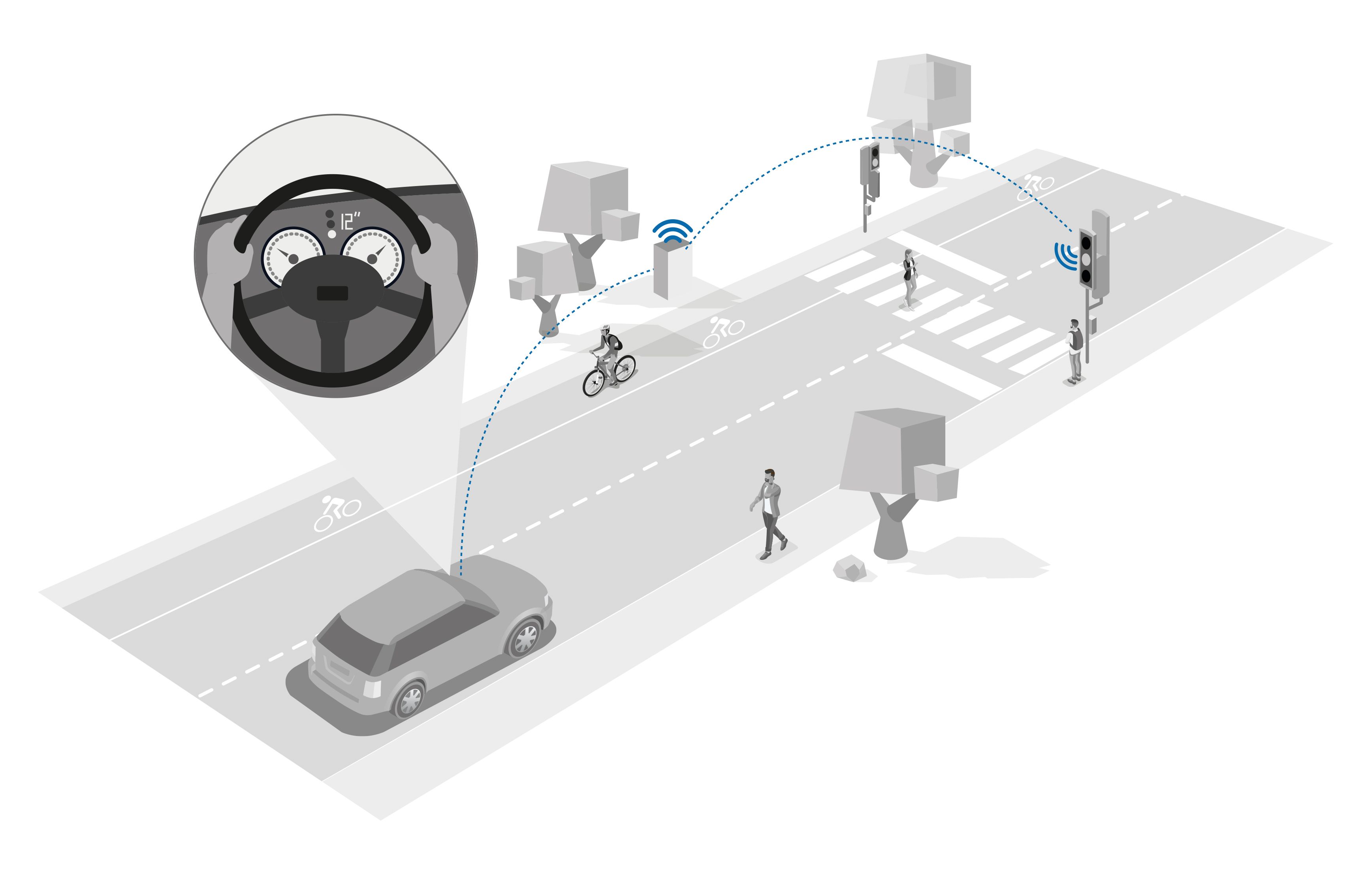
Better inform road users
With C-ITS, information on the current and future signalling of a traffic light system can be communicated, for example green time forecasts. If the road users know about their individual green wave, this results in energy savings, significantly less pollution and minimized stops, which conveys at the same time a positive city image. Also, cyclists and other road users can enjoy a more attractive driving experience.
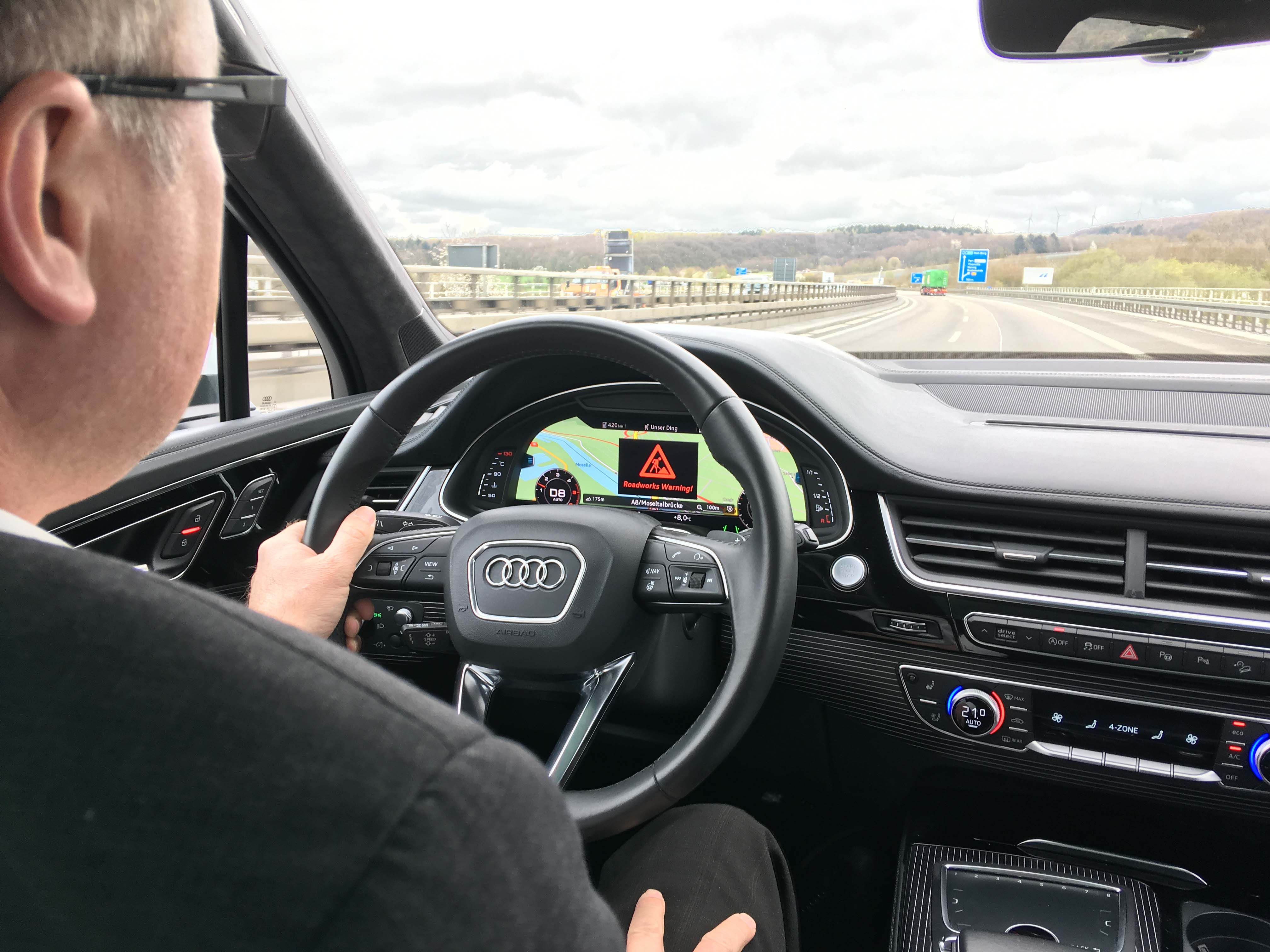
Warn of hazards
In the same way as safety trailers hint at roadwork zones on motorways via C-ITS, this technology can be used on the entire road network to warn of hazards, such as black ice or heavy rain, and this even without mobile internet.
Other than the selective, local identification, C-ITS is able to observe equipped vehicles every second over a certain distance (up to several hundred meters). This enables live statistics on waiting times, number of stops, congestion lengths, turning relations at intersections, and speed detection. In addition to these examples, there are further C-ITS uses that make traffic management safer and more efficient.
Technology
The system technology consists of several building blocks. Decisive elements such as message formats or communication channels are standardized. The devices, the software and their integration into existing technologies are available on the market. The most important elements are listed in the following overview:
Standardised messages
- CAM: The "Cooperative Awareness Message" (ETSI EN 302 637-2) describes the position, speed and direction of a vehicle. The message is regularly emitted from vehicles between 1 to 10 Hz. Optional contents are e.g. R09.16 telegrams or "rotating blue lights on."
- DENM: "Decentralized Environmental Notification Message" (ETSI EN 302 637-3) describes the coding of hazard warnings.
- IVI: "In-Vehicle Information“ (ISO 19321) regulates the coding of traffic signs, including, for example, dynamic speed limit signage.
- SPAT/MAP (SAE-J2735 and ISO 19091): „Signal Phase And Timing“ can include both the current signalling status and its forecast. By referencing to the standardised description of the intersection topology (MAP), it becomes clear for which signal group or driving relation the signalling is valid. MAP displays lanes and stop lines by means of coordinate dots. Like all messages, SPAT/MAP can either be sent locally (useful for applications that require very accurate and safe signalling information) or transmitted via Internet (useful for the dissemination of forecasts for certain applications, e.g. the waiting time at a signal-controlled intersection).
Communication channels
At first, C-ITS was developed for a local communication ("short range"). In a worldwide defined frequency range of 5.9 GHz, vehicles and infrastructure can directly communicate with each other. A mobile communications network is not necessary for this. The modem necessary for this kind of communication is part of the Road Side Unit, the C-ITS complement of the infrastructure. On the vehicle side, corresponding hardware can be retrofitted. In the VW Golf 8 it is already a standard. The first generation of short-range communication is called "ETSI ITS G5" or "802.11p". Another generation of short-range communication enters the market under the names of "C-V2X" or "PC5". Due to integrated chipsets for C-V2X and 5G mobile communication, several carmakers plan to equip their vehicles with this technology.
In addition, the generated messages can also be transmitted via the Internet. The information made available can then be sent via mobile communication to the road users. 5G promises more bandwidth and secured networks with guaranteed availability and fast local processing power ("Mobile Edge Computing"). This constitutes already today and even more in the future an important technological building block in modern networked traffic management.
New roles and tasks, more options
Just by buying and installing new hardware the benefit is not or only partially accessible. A traffic system operator must understand his role and the related new tasks and has to co-design the technological transformation. This also implies the build-up of knowledge about connected systems, IT security and the protection of privacy in terms of GDPR, critical infrastructures or ISO 27001.
Operators of traffic systems have a strong starting point to contribute to new applications and thus to determine their quality. So, for example, every traffic planner has the layout of an intersection and the corresponding signal program with its signal groups at his fingertips. From this he can quite easily create a MAP. Navigation map services are not able to reach this level of knowledge, quality and up-to-dateness. The MAP is also the basis for new functions. It is possible to process the number of vehicles flowing into an intersection (possibly even to the exact lane), their expected arrival times and the presence of pedestrians and cyclists. So, it is worthwhile for the planner to create and maintain the MAP, as it takes only little time and effort. The signal programme knowledge can also be processed for a traffic light forecast. Meanwhile it has been proven that even with dynamic and adaptive control in very many cases a good forecast is possible. In different scenarios it was demonstrated that the knowledge about an upcoming traffic light switch is beneficial for an energy-saving and efficient handling of traffic.
It is not surprising that the provision of this function directly from traffic technology and locally on site at the intersection promises the best results. Under certain conditions, a centrally generated forecast can be an option as well. In certain cases, this is the quicker way to get area-wide coverage. Those who have not yet or only barely engaged with these developments are often overwhelmed by the system. Ten years of development have generated a large amount of knowledge and experience in the field of C-ITS. Now it is time to apply the status quo of the developments in order to responsibly design our future.
Download our Whitepaper